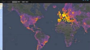
As shown by the photos posted by users on Google Maps/Google Earth services
Google is launching yet another very interesting project, Sightsmap, a world map with the most photographed areas of the Earth, as revealed by photos posted by users on Google Maps/Google Earth services with geolocation enabled.
On the map you will see different “lightings”. The more intense the light, the greater the popularity (more photos). So far, New York is in first place, followed in order by Rome, Barcelona, Paris and Istanbul.
Of course, the more you focus on the map, the more places you will see and you can see their ranking (e.g. Athens is ranked 35th worldwide and Lycabettus Hill is ranked 1st in Athens, and so on), as well as photos uploaded by users.
Here is the Athens Sightsmap https://www.sightsmap.com/
Source: protothema.gr